MapsOnline communities employ more than one MapsOnline website in order to serve their staff and local residents. We enable our clients to implement multiple sites in order to provide the right functionality and mapping layers for different user groups. The result is a complete online mapping solution that is capable of more than just providing public access to a GIS....MapsOnline can serve as the core component of your entire GIS program.
![]()
UPLOAD & ACCESS DATA
MapsOnline enables your community to upload your assessing data 24/7/365. You can even decide to update your assessing data for your staff’s use but “freeze” the assessing data for the public’s use until the end of the year. This flexibility allows your GIS program to benefit from having the latest assessing information available to all departments without publicizing your data prematurely. And, PeopleGIS can setup your MapsOnline to include all condominium records from your assessing database.
![]()
EXTENDED FUNCTIONALITY
MapsOnline provides additional value beyond simple public access tools
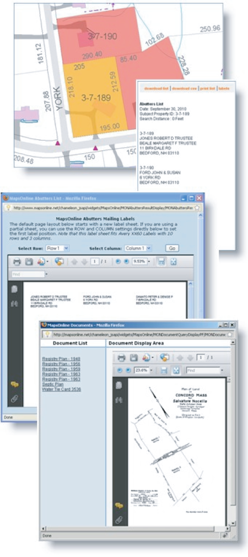
Avery Mailing Labels
Quick-Zoom Tools
Query Tools
Multi-Media Integration
Virtual Tour Integration
Document Management
Tiled-Mapping
Multi-Coordinate Systems
Public Safety Data Integration
UNBEATABLE PLATFORM
Latest Mapping Technologies
Incredible Cartography
Full Screen Mapping
Tiled & Dynamic Mapping Layers
Unlimited Mapping Layers
Google-Simple
Unlimited Mapping Sites
Real-Time PeopleFORMS
Edit Maps w/Ease
Integrated Doc Managementg
Print to Any Size Paper
For All Departments
![]()
Compile lists and print to Avery Labels directly
![]()
Integrate virtual tour photography into your MapsOnline site
![]()
Link photos to map features that pop-up as you hover over them on the screen
![]()
Customize MapsOnline sites for the Public or any of your departments
![]()
Built-in security measures and access controls
![]()
Deliver your GIS to every member of your staff and/or the public at a low cost
IF YOU BELIEVE THAT YOUR COMMUNITY SHOULD KNOW MORE ABOUT PEOPLEGIS AND SIMPLICITY, CONTACT US.